
|
Videowalks |
| Downloadable walk guides for PC and mobile devices |

|
|
Videowalks |
| Downloadable walk guides for PC and mobile devices |
Video run time: 26 minutes 18 seconds

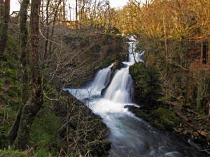
A circular from Elterwater village initially following the Cumbria Way past Elterwater itself and on past Skelwith Force to reach Skelwith Bridge. On this section there are great views back towards the Langdales. There is a cafe at Skelwith Bridge. From there the Cumbria Way is followed to Colwith Force, another delightful waterfall in some secluded woods and then on to the much photographed Slater Bridge. The walk heads on by Little Langdale, with views of Little Langdale tarn before heading back down to Elterwater.
|
Best gifts for walkers - 35 top presents for hikers under £35 If you are wondering what to buy someone who likes walking, or searching for those inexpensive or personalised gifts for hikers, then look no further. We've put together a selection of practical presents under £35 that any walker or hiker in the UK would like to receive. Read our article: Best gifts for walkers - 35 top presents for hikers under £35 |
|
What to wear and take on your walk: If you are new to walking and want to know what to wear and take on your walk, or just want to know what to consider when buying your walking clothes and equipment then these articles are for you. We'll also take you through our favourite walking boots, walking jackets, walking trousers, rucksacks, backpacks, water bottles, mapping and safety equipment etc. of 2024. Read our articles: What to wear on a walk and What to take on a walk |
| Parking: | National Trust pay and display car park in Elterwater at the start of the walk (grid reference NY 327 047) - other parking is available in Elterwater. |
| Directions: | Google Maps: get directions here / What3words: custard.dressings.bicker |
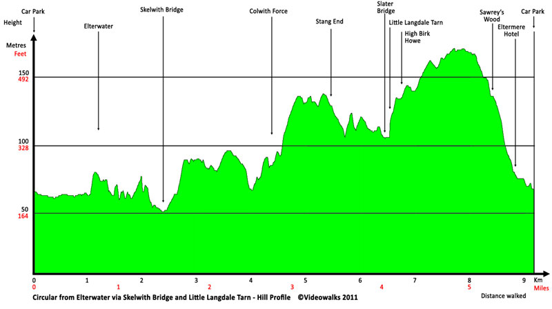
| Walk distance: | 5.8 miles (9.3 Km) |
| Estimated walk time: | 2 hours 45 minutes |
| Height climbed: | 355 metres |
| Grade: | 2-B: A medium length walk that requires modest uphill walking |
| Peaks / summits: | None of note |
| Wainwrights: | None |
| Map: | Ordnance Survey - Explorer OL7 (The English Lakes - South-eastern Area) Buy this map from Ordnance Survey |
| Walk features: | Birds, Cafe, Flowers, Hills or Fells, Pubs, Stream or River, Views, Waterfall, Wildlife |
| Facilities / refreshments: | 2 Pubs in Elterwater and a cafe part way round the walk at Skelwith Bridge |
| Nearest town: | Walk starts in Elterwater - Ambleside is approximately three miles away |
| Local accommodation: | View accommodation close to the start of this walk from Sykes Holiday Cottages or from Holidaycottages.co.uk |
| Walk Tags: | Video walk, Elterwater, Lake District, walk, Cumbria, National Trust, Cumbria Way, Loughrigg Fell, Skelwith Force, Skelwith Bridge, Chesters, Park Farm, Colwith Force, High Park, Stang End, Slater Bridge, Little Langdale, Little Langdale Tarn, Lingmoor Fell, Dale End, Elterwater Hall, Eltermere Hotel, Britannia Inn, Wainwright, Great Langdale Beck, River Brathay |
| Video run time: | 26 minutes 18 seconds |
Hill profile:
Video preview:
Downloads are available in different resolutions for your PC, SmartPhone and other mobile devices and are provided in mp4 format for maximum compapability with a wmv version also available. You also receive a PDF document with the walk details and an Ordnance Survey map extract that you can print out or view on your mobile device. Watch the video on your PC or burn to a CD or DVD to watch on your TV to see in detail the walk before you set off.
All downloads are available instantly.
Once saved to you device, you can then play them an unlimited number of times whenever you want!


