
|
Videowalks |
| Downloadable walk guides for PC and mobile devices |

|
|
Videowalks |
| Downloadable walk guides for PC and mobile devices |
Video run time: 25 minutes 53 seconds

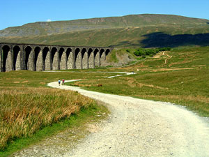
A circular from the Ribblehead Viaduct over one of the 'Yorkshire Three Peaks'. The walk follows the 'Three Peaks walk' path for most of its route, initially following alongside the Settle to Carlisle railway line, before heading up on the path towards Dent. The path then steepens over Knoutberry Hill before following a wall along to the summit of Whernside. The panorama from here ranges from Pendle Hill to the South, round to the Morecambe Bay and then the Lakeland Fells and the Howgills. The return is via a steep drop down to Bruntscar, before leaving the 'Three Peaks path' to turn left eventually passing Winterscales to come out through a tunnel under the railway. The outward path is then followed for the short journey back to the parking area.
|
Best gifts for walkers - 35 top presents for hikers under £35 If you are wondering what to buy someone who likes walking, or searching for those inexpensive or personalised gifts for hikers, then look no further. We've put together a selection of practical presents under £35 that any walker or hiker in the UK would like to receive. Read our article: Best gifts for walkers - 35 top presents for hikers under £35 |
|
What to wear and take on your walk: If you are new to walking and want to know what to wear and take on your walk, or just want to know what to consider when buying your walking clothes and equipment then these articles are for you. We'll also take you through our favourite walking boots, walking jackets, walking trousers, rucksacks, backpacks, water bottles, mapping and safety equipment etc. of 2024. Read our articles: What to wear on a walk and What to take on a walk |
| Parking: | Roadside laybys near to the 'T' junction of the B6255 and the B6479 (grid reference SD 765 793) - further parking is available near to the Station Inn, but please park responsibly as it can get very busy around this area, especially as weekends |
| Directions: | Google Maps: get directions here / What3words: response.trickling.sweeping |
| Walk distance: | 8.4 miles (13.4 Km) |
| Estimated walk time: | 3 hours 50 minutes |
| Height climbed: | 525 metres |
| Grade: | 3-C: A long walk that has rugged terrain and some steep climbs |
| Peaks / summits: | Whernside (736m) |
| Map: | Ordnance Survey - Explorer OL2 (Yorkshire Dales - Southern & Western Area) Buy this map from Ordnance Survey |
| Walk features: | Birds, Flowers, Geographic feature, Hills or Fells, Pub, Railway, Stream, Views, Waterfall, Wildlife |
| Facilities / refreshments: | Station Inn at the Ribblehead viaduct and there is often a caravan selling tea/coffee bacon sandwiches etc in the layby by the 'T' junction at the start and end of the walk |
| Nearest town: | Walk starts near to the Ribblehead viaduct, nearest larger towns Settle or Ingleton |
| Local accommodation: | View accommodation close to the start of this walk from Sykes Holiday Cottages or from Holidaycottages.co.uk |
| Walk Tags: | Video walk, Whernside, Ribblehead viaduct, Settle to Carlisle railway, Yorkshire Dales, Yorkshire Three Peaks, Three Peaks, Yorkshire Dales National Park, Limestone, Batty Green, Bleamoor, Bleamoor Signal Box, Slack Hill, Grain Ings, Knoutberry Hill, Greensett Tarn, Greensett Moss, Bruntscar, Winterscales |
| Video run time: | 25 minutes 53 seconds |
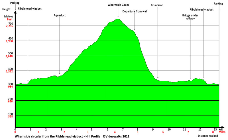
Hill profile:
Downloads are available in different resolutions for your PC, SmartPhone and other mobile devices and are provided in mp4 format for maximum compapability with a wmv version also available. You also receive a PDF document with the walk details and an Ordnance Survey map extract that you can print out or view on your mobile device. Watch the video on your PC or burn to a CD or DVD to watch on your TV to see in detail the walk before you set off.
All downloads are available instantly.
Once saved to you device, you can then play them an unlimited number of times whenever you want!


