
|
Videowalks |
| Downloadable walk guides for PC and mobile devices |

|
|
Videowalks |
| Downloadable walk guides for PC and mobile devices |
Video run time: 14 minutes 26 seconds

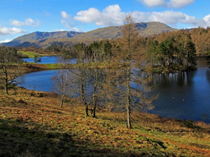
Tarn Hows is claimed to be the most photographed place in the Lake District and receives up to 250,000 visitors per year. The walk itself needs very few directions, as it simply follows the wide, even gravel path around the tarn from the National Trust car park. The path, created by the National Trust, is interspersed with benches from which the views can be admired. It can get quite busy around the Tarn, so early morning or late afternoon are the best to avoid the crowds! There are views all around to the surrounding fells of Coniston Old Man, Wetherlam, the Langdale Pikes and the Helvellyn range.
|
Best gifts for walkers - 35 top presents for hikers under £35 If you are wondering what to buy someone who likes walking, or searching for those inexpensive or personalised gifts for hikers, then look no further. We've put together a selection of practical presents under £35 that any walker or hiker in the UK would like to receive. Read our article: Best gifts for walkers - 35 top presents for hikers under £35 |
|
What to wear and take on your walk: If you are new to walking and want to know what to wear and take on your walk, or just want to know what to consider when buying your walking clothes and equipment then these articles are for you. We'll also take you through our favourite walking boots, walking jackets, walking trousers, rucksacks, backpacks, water bottles, mapping and safety equipment etc. of 2024. Read our articles: What to wear on a walk and What to take on a walk |
| Parking: | The National Trust pay and display car park at the Southern end of the tarn (grid reference SD 326 995). Following the road from Hawkshead to Coniston (B5285), turn right at Hawkshead Hill and follow the signs for Tarn How for just under a mile to reach the National Trust car park. The continuing road (turning left out of the National Trust car park), which rejoins the Hawkshead to Coniston road nearer to Coniston is one way and cannot be driven up from the Coniston end. |
| Directions: | Google Maps: get directions here / What3words: baths.hunk.pleasing |
| Walk distance: | 1.75 miles (2.8 Km) |
| Estimated walk time: | 50 minutes |
| Height climbed: | 105 metres |
| Grade: | 1-A: A short walk that is generally very flat |
| Peaks / summits: | None |
| Wainwrights: | None |
| Map: | Ordnance Survey - Explorer OL7 (The English Lakes - South-eastern Area) Buy this map from Ordnance Survey |
| Walk features: | Birds, Flowers, Geographic feature, Stream or River, Tarn, Views, Wildlife, Woodland |
| Facilities / refreshments: | Toilets and information centre on National Trust car park at Tarn Hows. Pubs, cafes and more toilets in Coniston about 1.5 miles away |
| Nearest town: | Coniston |
| Local accommodation: | View accommodation close to the start of this walk from Sykes Holiday Cottages or from Holidaycottages.co.uk |
| Walk Tags: | Video walk, Lake District, Cumbria, Tarn Hows, Coniston, National Trust, Tom Heights, Rose Castle plantation, Old Man of Coniston, Wetherlam, Langdale Pikes, Helvellyn range, Videowalks, Beatrix Potter |
| Video run time: | 14 minutes 26 seconds |
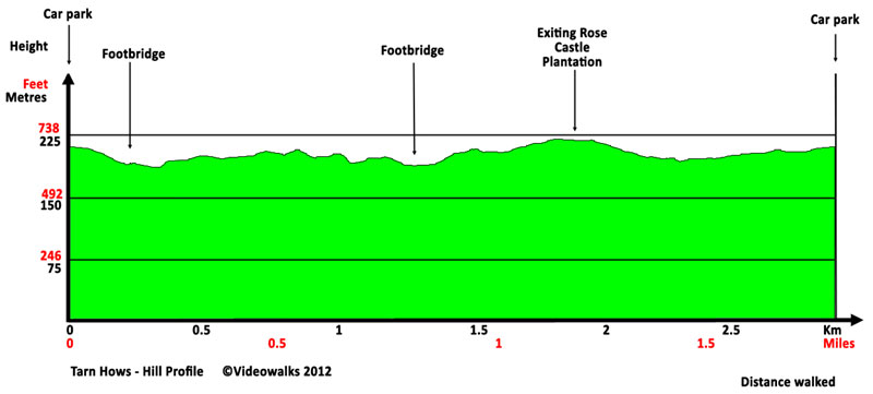
Hill profile:
Video preview:
Downloads are available in different resolutions for your PC, SmartPhone and other mobile devices and are provided in mp4 format for maximum compapability with a wmv version also available. You also receive a PDF document with the walk details and an Ordnance Survey map extract that you can print out or view on your mobile device. Watch the video on your PC or burn to a CD or DVD to watch on your TV to see in detail the walk before you set off.
All downloads are available instantly.
Once saved to you device, you can then play them an unlimited number of times whenever you want!


