
|
Videowalks |
| Downloadable walk guides for PC and mobile devices |

|
|
Videowalks |
| Downloadable walk guides for PC and mobile devices |
Video run time: 35 minutes 41 seconds

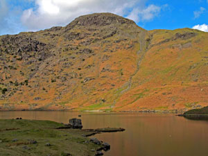
Tarn Crag is arrived at by way of visiting two delightful tarns - Easedale Tarn and Codale Tarn. Grasmere is left via Easedale Road and then a short steep path is followed by the waterfall up the side of Sourmilk Gill to reach Easedale Tarn, which backed by Tarn Crag is a place to stop and linger and a popular place for picnics. The walk heads on up another steep path to pass behind Belles Knott to reach Codale Tarn, a much quieter place to stop and rest. Then on about seven hundred metres to Tarn Crag - the path on this section is indistinct in places and is probably best avoided in mist or bad visibility unless your map and compass skills are very good. Tarn Crag affords wonderful views of the Helvellyn range and over Easedale towards Rydal Water and Windermere. A ridge is then followed down in to Far Easedale Gill on the return back to Grasmere.
|
Best gifts for walkers - 49 top presents for hikers under £35 If you are wondering what to buy someone who likes walking, or searching for those inexpensive or personalised gifts for hikers, then look no further. We've put together a selection of practical presents under £35 that any walker or hiker in the UK would like to receive. Read our article: Best gifts for walkers - 49 top presents for hikers under £35 |
|
What to wear and take on your walk: If you are new to walking and want to know what to wear and take on your walk, or just want to know what to consider when buying your walking clothes and equipment then these articles are for you. We'll also take you through our favourite walking boots, walking jackets, walking trousers, rucksacks, backpacks, water bottles, mapping and safety equipment etc. of 2025. Read our articles: What to wear on a walk and What to take on a walk |
| Parking: | The walk starts from the junction of Easedale Road and Broadgate in Grasmere opposite Sam Read's bookshop (grid reference NY 337 076) - There are quite a few pay and display car parks in Grasmere. |
| Directions: | Google Maps: get directions here / What3words: ladder.obey.firewall |
| Walk distance: | 7.0 miles (11.2 Km) |
| Estimated walk time: | 3 hours 40 minutes |
| Height climbed: | 590 metres |
| Grade: | 2-C: A medium length walk that has rugged terrain and some steep climbs |
| Peaks / summits: | Tarn Crag |
| Wainwrights: | Tarn Crag (Easedale): 1801ft / 549m - 150th highest |
| Map: | Ordnance Survey - Explorer OL7 (The English Lakes - South-eastern Area) Buy this map from Ordnance Survey |
| Walk features: | Birds, Cafe, Flowers, Hills or Fells, Lakes or Tarns, Pubs, Stream or River, Views, Waterfall, Wildlife |
| Facilities / refreshments: | Many pubs and cafes in Grasmere |
| Nearest town: | Walk starts in Grasmere |
| Local self-catering accommodation: | View self-catering accommodation close to the start of this walk from Sykes Holiday Cottages or from Holidaycottages.co.uk |
| Local hotels, inns and B&Bs: | View hotels and inns close to the start of this walk from The Inn Collection Group |
| Walk Tags: | Video walk, Grasmere, Videowalk, Videowalks, Video walks, Lake District, Easedale Road, Easedale Beck, Grasmere Youth Hostel, New Bridge, Sourmilk Gill, Easedale Tarn, Tarn Crag, Brinhowe Crag, Stythwaite Steps, Blea Crag, Eagle Crag, Belles Knott, Codale Tarn, Stenners Crag, Far Easedale Gill, Wainwright, Wordsworth |
| Video run time: | 35 minutes 41 seconds |
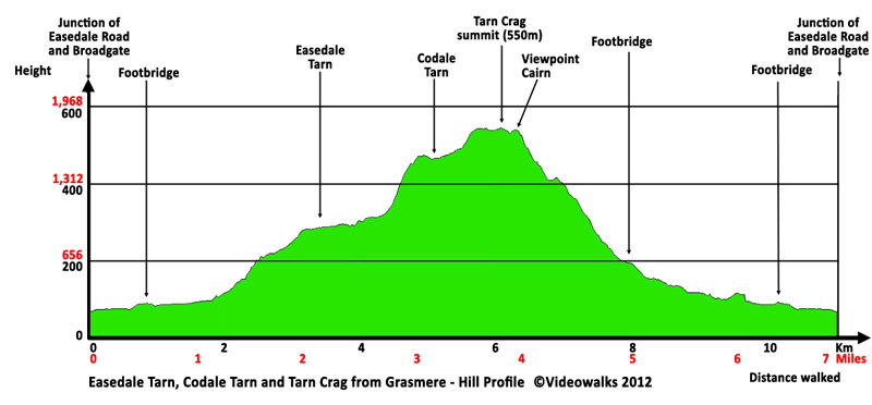
Hill profile:
Downloads are available in different resolutions for your PC, SmartPhone and other mobile devices and are provided in mp4 format for maximum compapability with a wmv version also available. You also receive a PDF document with the walk details and an Ordnance Survey map extract that you can print out or view on your mobile device. Watch the video on your PC or burn to a CD or DVD to watch on your TV to see in detail the walk before you set off.
All downloads are available instantly.
Once saved to you device, you can then play them an unlimited number of times whenever you want!

